Lissa Myers' Monte Ne Photos

|
|---|
|
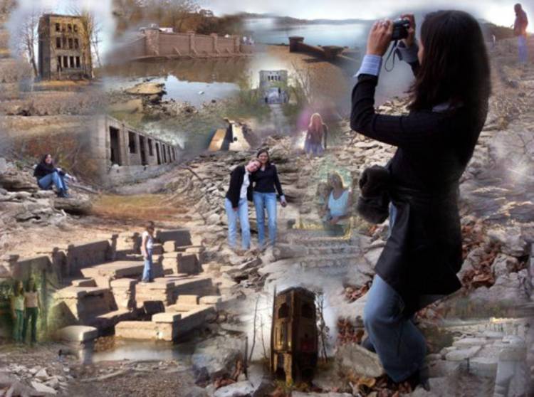
This is the woman behind the camera. She says her friend, Mandy, inspired her to do these photos and put the montage together. The Beaver Lake water level usually reaches the top of this wall, which is behind (south of) the amphitheater. Because of the severe drouth in Arkansas in 2005, the lake level dropped low enough (1105.7 feet above sea level) to reveal the base of this wall and the top three 'bench' levels of the amphitheater. The amphitheater was built around the "Big Spring" that supplied water for the lagoon that led to Oklahoma Row, W. H. 'Coin' Harvey's log hotel. He claimed that Oklahoma Row was the biggest log building in the world. It was built on a point of land above and to the west of the main part of the town of Monte Ne, which Harvey developed in the early twentieth century. That was about a half mile north of this location. Harvey even built a rail line from Lowell, Arkansas, to a location near where Lissa is standing to bring tourists to his resort. The tourists had a choice of riding an Italian Swan Boat up the lagoon from the spring to Oklahoma Row or walking along the east bank of the lagoon to the hotel. |

|
|---|
|
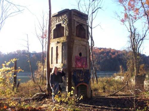
Oklahoma Row was on the east side of the north end of the lagoon. The large log structure was removed before the lake was filled but this three-story 'tower' was left standing. Old photo postcards show Oklahoma Row with the tower at the south end. The log structure was built on a concrete foundation which included basement rooms. The average lake level fills the basement rooms and occasionally high water levels reach the top of the foundation. |

|
|---|
|
Lissa caught the early morning light at just the right time to get this artistic photo of a first floor room in the tower and then got this great foggy view through the windows out over the lake. |

|
|
|---|
|
This small concrete structure seems to be a two-story fireplace of some sort. It is east of Oklahoma Row and closer to the Monte Ne town site. Several other foundation structures are further to the east and they may be associated with Missouri Row or the indoor swimming pool. In the early 1960s this area was so overgrown with brush and trees that these structures were not obvious to the casual visitor. |
|
|---|
|
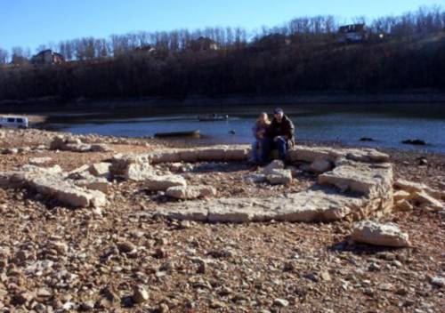
Unidentified tourists are sitting on the old foundation east of the chimney structure. The east bank of this part of Beaver Lake is in the distance. The next photo shows the foundation from the east side. |

|

|
|---|
|
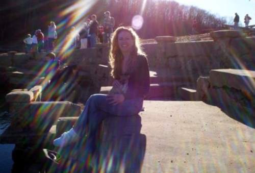
Now that Monte Ne has become such an attraction, one must arrive early to get a photo without the crowd. Back at the south end of the lagoon now, the wall that Lissa was standing by is in the center background behind the amphitheater. There once were two more columns at this end of the upper part of the amphitheater. The highest column, which formed this end of the upper wall, disappeared soon after the lake was filled in 1965. The second on down from the top (near the tree stump) was there at least until 1977. There is evidence that the amphitheater was built sometime between 1926 and 1932 when Coin Harvey was a candidate for president. |

|

|
|---|
|
These views from the east shore or from a boat give a different pespective on the amphitheater and the 'wall.' |

|

|
|---|
|
Bouncing back to the north side, Lissa and her friend Mandy sit by the fireplace structure and finally Lissa poses at the amphitheater with the late afternoon winter sun behind her. |
|
 Mandy, Jim, and Lissa |
|---|
|
And finally on February 4, 2006, the three of us met at Monte Ne and posed for this photo on the second couch down from the top on the north end of the west wall of the amphitheater. |
| See bottom of this page for LINKS TO OTHER WEB SITES RELATED TO MONTE NE AND COIN HARVEY |


Friends of Monte Ne!Can the Friends of Monte Ne be reorganized now that there is such great interest in the lost resort? With proper organization, planning, and fund raising, some nice things could be done in the area by the Lake at old Monte Ne.
It would help to have someone with connections to the local district of the Army Corps of Engineers, the State Parks Department, and maybe some of the local politicians. If you're interested, e-mail me at jamesmskipper1141@att.net and I will pass it on to the interested people who live in the area. |
| THE INDEX OF PAGES FOR THIS ARTICLE |
| PAGE 1 - The story of Coin Harvey and Monte Ne with photos of the amphitheater. |
| PAGE 2 - Concrete Bank Block Building and Views of the Lagoon |
| PAGE 3 - Lodge, Burial Vault, and Photos with the Lake at Three Levels |
| PAGE 4 - 1977 Lake Level marked on Old Photos, Views into the Water, Checking the Time Capsule, Related Links |
| PAGE 5 - Lissa Myer's Current photos of the ruins at Monte Ne: the Tower Windows, old foundations, and crowds at the amphitheater. |
| PAGE 6 - 2005 Views of Oklahoma Row foundation and tower with a new summary of the events of William Hope "Coin" Harvey's involvement with his Monte Ne Resort and the good roads movement. This page includes many links to other informative web sites related to Coin Harvey and Monte Ne. |
| PAGE 7 - Photo and map of the old townsite with a panoramic photo of some of the foundation ruins on the lake shore and across the lake to the amphitheater. There is a photo that shows the new location of Harvey's tomb. The text includes some comments from a U.S. Corps of Engineers employee who toured the Monte Ne site for the Corps in the early 60s. |
| PAGE 8 - Coin Harvey's Amphitheater around the Big Spring at Monte Ne. Harvey planned this to be the foyer for his pyramid or obelisk in which he planned to place a"time capsule" or museum room to hold all the important documents and marvels of civilization. However, that was never to be because he was unable to obtain financing. The photos on this page show the upper parts of the amphitheater now exposed by the dropping waters of Beaver Lake. Old photos from before the lake was built and at other times when the lake was low are included for comparison. |
| PAGE 9 - This page continues the amphitheater description with the south wall. Most of the south wall is under water even with the lake level at 1106 feet above sea level. The south wall may have been the planned entrance to the pyramid and time capsule that Coin Harvey wanted to build. In any case, he probably planned to build the pyramid, or obelisk, on the little hill behind the amphitheater. That little hill is an island when the lake level gets to the 1120 to 1125 range as shown in the photo posted on the previous page. |
| PAGE 10 - On the side of the hill behind the south wall is a tall retaining wall. The area was so covered in brush in 1961 and I was so hesitant about the possibility of trespassing that I didn't find that wall. There is a paved driveway leading from the east of the amphitheater up to the area above the wall where the railroad depot used to be. There are also panoramice photos of the view from the amphitheater back toward the old Monte Ne town site. |
| PAGE 11 - Selected Monte Ne Resort photos from the Rogers Historical Museum used by permission. Photo of old Monte Ne in great detail. Photos of the Bank Block when new and years later after it had been gutted by fire or weather. Photos of the amphitheater from its unfinished construction in 1928 and when that part of Beaver Lake was dry in the winter of 1977. |
| PAGE 12 - 2006 Wedding in the Monte Ne amphitheater. First wedding there in more than 40 years? Photo of Ann in the amphitheater in 2006 compared to a similar photo from 1977. |
| PAGE 13 - Photos comparing the low lake level in January 2006 with the same areas in January 2007 after the lake level rose about 20 feet. |