Coin Harvey's
Monte Ne Resort - 2005/2006
 |
|---|
This old slide from 1968 shows the Oklahoma Row foundation and Tower just a few years after the log sturcture was removed. Vegetation is already beginning to take over. The lake level was very high that year and filled the rooms in the base of the foundation. An automobile is parked on the foundation. There is a tree beyond the automobile, then another to the right, and then a third tree further to the right. Way beyond the third tree is the little hill behind (southwest of) the amphitheater. That hill was an ‘island’ because of the high water level. If you have looked at previous pages in this article, you have seen a photo of the island from a point on the lake shore near the amphitheater. |
I think it's time for a summary.
William Hope "Coin" Harvey was involved with the elections of 1896 on the side of William Jennings Bryan and the issue of the free coinage of silver. Read this article by Richard F. Snow from American Heritage Magazine that tells about his influence and the influence of his financial advice book, Coin’s Financial School. It seems that he was disillusioned by Bryan's loss and he put his heart into the development of a health resort in the Ozarks of northwest Arkansas near Rogers. He was 50 years old when he moved to the Monte Ne area. He bought 320 acres of the picturesque hills and valleys with spring-fed streams in the Silver Springs area and began development and opened the resort in 1901 according to old reports from the Arkansas Old State House Museum web site.
This page from Arkansas' Old State House Museum collection says that Harvey coined the name "Monte Ne" which he said meant "mountain waters" as the name for his resort and the town he developed nearby. He dammed the streams to form lagoons fed by the area springs and imported Venetian "Swan Boat" gondolas for travel along the lagoons. He built at least two large log lodges, Missouri Row and Oklahoma Row, on the high banks of the lagoons. According to this article from the Old State House Museum site. The article descibes the parties and features of the resort and says this in one paragraph: "Guests coming to stay at Monte Ne arrive by way of the Monte Ne Railroad and can either walk the short distance from the station around Big Spring to their hotel, or can be transported over the lagoon in a gondola that Harvey imported from Venice. The two hotels, Oklahoma Row and Missouri Row, are separated by a wide landscaped lawn."
He formed a bank and built a two-story concrete "Bank Block" in 1905. The bank was closed in 1914. Depositors and lenders were paid off and any other funds were transferred to a bank in Rogers.
The "Big Spring" at the south end of the lagoon from Oklahoma row was surrounded by a boardwalk by 1908 and passengers on the railroad spur that Harvey built from nearby Lowell could walk from the train to the spring and board the Swan Boat for a ride up the lagoon to Oklahoma Row. The rail spur was closed in 1910 as more and more tourists began driving automobiles.
Harvey became involved in the "good road" movement and work with the Ozark Trails Association which identified, marked, and improved roads throughout southwest Missouri, northwest Arkansas, Oklahoma, the Texas panhandle, and on into New Mexico. It eventually became evident that private groups would not be able to establish a road system adequate for the tremendous growth in automobile travel so the federal government was convinced to take the responsibility in the mid-twenties. This article from Arkansas' Old State House Museum tells about Harvey's participation. Also, be sure to read this 1926 journal of a nineteen-year-old woman who drove her mother and sister from Pine Bluff to Eureka Springs and on to Monte Ne for a week's stay there. The journal was linked on an earlier page, also. They were in a single-seat Ford coupe, so only the three of them could go. They drove at least part of the way on Scenic Arkansas Highway 7 because they had to stop in Jasper for repairs. The young woman's portrait is included with the article. She didn't mention the amphitheater, so perhaps it had not been built yet.
World War I cut into Harvey's resort business and his financial situation was getting worse. He was discouraged and became convinced that civilization was going to end soon. He wanted to built an obelisk, or pyramid as it became known, to hold a record of civilization. He estimated the height of the obilisk based on his idea that the mountains would all level out and the area would fill with lava and he wanted the top of the obelisk to remain visible. The obilisk was to be 40 feet square at the base and 130 feet high. The cost was estimated at $100,000 and he was no longer able to get that kind of financing together. He didn't build the time capsule or the obelisk, but he did build an amphitheater around the Big Spring at the south end of the lagoon. The amphiteater would have served as the entrance to the base of the obelisk if it had ever been built. The following is quoted from the American Heritage article by Richard F. Snow linked earlier. "He actually began work on this great monument but gave up when he found he would have to raise one hundred thousand dollars. He did, however, complete what he called the foyer, a strange scattering of stone and concrete hummocks. ... He lived until 1937, fully four decades after his moment of national prominence. But even at the end, he wasn’t totally forgotten. His “foyer” became something of a tourist attraction. More and more visitors drove up to Monte Ne, wandered through the broken jumble of masonry, and paid a small admission fee to a slender, clear-eyed old man who liked to lecture them about financial reform." Perhaps Snow had never seen the amphitheater. He also missed the year of Harvey's death. BTW - There may be errors in my reporting, too. I checked these links on January 14, 2005.
Although Harvey promoted automobile traffic with the "good roads" movement in the teens and twenties, he may have turned against the automobile as he got old. This old newspaper article says that he blamed automobile exhaust for the drought of 1934.
Harvey was drafted to run as the presidential candidate for the Liberty Party in the election of 1932, when F.D.R. was first elected president. The Liberty Party convention was held in the amphitheater at Monte Ne. Harvey got very few votes in the election, his bank at Monte Ne had failed in earlier years, his plans for the "pyramid" went nowhere and he died four years later at the age of 85 on February 11, 1936. That was exactly four years before my Grandfather Skipper died and exactly five years before I was born. This article from the February 12, 1936, Huntington Herald-Dispatch, of Huntington, West Virginia, gives an extensive obituary. It provides an excellent summary of his life and opinions.
Twenty years later the amphitheater around the Big Spring was still being used for outdoor meetings and the area around that end of the lagoon was a picnic area. Oklahoma Row was rented out for college dance parties and that sort of thing. Summer camps and various other activties were held in the area, but the Bank Block was just a concrete shell and most other stuctures were gone or hidden in the overgrowth.
Then in the early 1960s, the Army Corp of Engineers was directed to build a lake on the headwaters of the White River. There were other lakes further downstream and this one was to be the last. The spring-fed streams from Monte Ne formed one of the tributaries of the White River and the lake surface would reach high enough to cover the old amphitheater and lagoon and Harvey's burial vault and the old Monte Ne townsite, but not Oklahoma Row up on the ridge above the lagoon.
The burial vault was moved to higher ground, the log structure of Oklahoma Row was moved partially intact to a location on the side of the road leading into Monte Ne, the concrete tower and foundation of Oklahoma Row were left in place on Corp of Engineer controlled federal property. The old Bank Block was reportedly knocked down as it was a potential hazard to boats on the lake. The amphitheater was left to be flooded by the lake, but the two concrete chairs were removed from the amphitheater podium to the Frisco Park in Rogers.
By 1965 or '66 the lake was filled to its normal level of about 1120 feet above sea level. That's at least five feet above the highest part of the amphitheater (but not that much above the large wall south of the amphitheater). In 1977 a drought and perhaps other factors caused the lake level to drop to about 1092 feet above sea level. That exposed the entire amphitheater for the first time in over ten years. The internet wasn't in place then, so the word didn't get around. I was there in July 1977 but the lake level was 1107 feet then. The lake was low again in the mid-80s and many people saw the amphitheater who had never seen it before.
Now, twenty years later, the amphitheater is again exposed to the gaze of a new generation. This time the internet has made it possible for people all over the world to find out what it looks like now and what it looked like in years past. As of the first of the year 2006, the lake level is holding at about 1106 feet. It would have to drop another 14 feet to expose the entire amphitheater and be back to the old lagoon level.
Time and the water have not been good for the amphitheater.
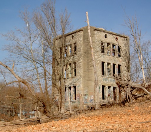
The old concrete lodge tower still seems to be in solid condition, but it is being defaced with graffiti in spite of its recent designation as a National Historic Place.
TODAY

|
|---|
1936 Benton County Road Map
Rogers/Monte Ne Area |
|---|
Reach Monte Ne by taking Highway 94 east from Highway 71 in Rogers. The first old Monte Ne feature you'll see is what remains of Oklahoma Row. It looks fair for a 100-year-old log structure, but the move from its original foundation and the modest restoration effort have left it just a sad reminder of its once glorius condition. Just watch for the red tile roof over a dark log structure on the left of the road before Monte Ne. These photos show the log structure as it was in 1977 viewed from the west before any restoration. Below that is a view taken in December 2005 from the road looking to the northwest.
The tower and concrete foundation of Oklahoma Row are the only features of Monte Ne still in their original location and above water all the time. The tower is probably the first thing you'll notice when you reach the old Monte Ne area and the lake. The photo on the left shows the tower from a point on the foundation near the barrior by the parking area. The other is a closer view showing my son Louis standing near one of the first floor doors.
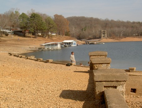
But where is the amphitheater or pyramid? Look at the lower right in the photo above. The amphitheater is on this side of the bare point of land that extends out into the lake. The photo on the left below shows the amphitheater in the distance beyond the corner of the tower. The wall behind the amphitheater is almost lined up with this corner, but it's a little off to the right. The other view is back toward the tower from that large wall behind the amphitheater. The large wall seems to line up with a point where the lagoon side entrance to Oklahoma Row would have been. That's about half way along the foundation beyond the tower. The lagoon was at the bottom of the little valley that ran from the amphitheater to the tower. A wide wooden stairway provided access to Oklahoma Row from the lagoon. The surface of the lagoon was about fourteen feet lower than the lake level is in this set of photographs. That meant that patrons would have had to climb about twenty-four feet of stairs to reach the lobby of Oklahoma Row.
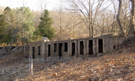
Now for a walk around the tower and foundation. It isn't possible to do this when the lake level is high. The photo on the left shows the southeast corner of the tower. The photo on the right is courtesy of Joan Leeser and it shows the west wall of the tower and the area of the foundation adjacent the tower. Some openings are visible in the side of the foundation in that area. Further along the foundation side is covered by the earth but the the farthest half is exposed as shown in the next set of photos.
This side of the Oklahoma Row foundation in the photo below is not usually visible. The normal lake level is close to the top surface or with a couple of feet of it. The lake level in December 2005 was about fourteen feet below normal so it's easy to explore and photograph this area. The rooms inside the foundation are variously described as servants' quarters or dressing rooms. The photo from the top of the foundation looks out over the arm of the lake that reaches up toward Arkansas Highway 94 when the lake level is high.


Friends of Monte Ne!
Can the Friends of Monte Ne be reorganized now that there is such great interest in the lost resort? With proper organization, planning, and fund raising, some nice things could be done in the area by the Lake at old Monte Ne.
- The old Oklahoma Row foundation and adjoining area could be cleared and made into a picnic area.
- A 1/10th-scale model of Harvey's proposed "pyramid" could be built near the Oklahoma Row tower.
- The tower could be restored and a log entry room could be built where the Oklahoma Row used to connect to the tower. The room could serve as the entry to the tower and as a museum and gift shop.
It would help to have someone with connections to the local district of the Army Corps of Engineers, the State Parks Department, and maybe some of the local politicians.
If you're interested, e-mail me at jamesmskipper1141@att.net and I will pass it on to the interested people who live in the area.
|
| LINKS: These are links to some of the
more interesting sites related to Monte Ne and Coin Harvey.
|
| Monte Ne - This web site "The American Local History Network - Benton County, Arkansas" has a copy of an old postcard from Monte Ne and some brief comments about the "pyramid." |
| Harvey's Connection to the Ozark Trails Association - This web site tells how Coin Harvey played a part in the effort 100 years ago to establish a system of roads in the Ozarks. The Association planned routes along existing roads and developed a system of road markers before the national highway system was started. |
| Beaver Lake -
Description of Beaver Lake with Link to Current Surface Level
|
| THE INDEX OF PAGES FOR THIS ARTICLE
|
| PAGE 1
- The story of Coin Harvey and Monte Ne with photos of the
amphitheater.
|
| PAGE 2
- Concrete Bank Block Building and Views of the Lagoon
|
| PAGE 3
- Lodge, Burial Vault, and Photos with the Lake at Three Levels
|
|
PAGE 4 - 1977 Lake Level marked on Old
Photos, Views into the Water, Checking the Time Capsule, Related Links
|
|
PAGE 5 - Lissa Myer's Current photos of the ruins at Monte Ne: the Tower Windows, old foundations, and crowds at the amphitheater.
|
|
PAGE 6 - 2005 Views of Oklahoma Row foundation and tower with a new summary of the events of William Hope "Coin" Harvey's involvement with his Monte Ne Resort and the good roads movement. This page includes many links to other informative web sites related to Coin Harvey and Monte Ne.
|
|
PAGE 7 - Photo and map of the old townsite with a panoramic photo of some of the foundation ruins on the lake shore and across the lake to the amphitheater. There is a photo that shows the new location of Harvey's tomb. The text includes some comments from a U.S. Corps of Engineers employee who toured the Monte Ne site for the Corps in the early 60s.
|
|
PAGE 8 - Coin Harvey's Amphitheater around the Big Spring at Monte Ne. Harvey planned this to be the foyer for his pyramid or obelisk in which he planned to place a"time capsule" or museum room to hold all the important documents and marvels of civilization. However, that was never to be because he was unable to obtain financing. The photos on this page show the upper parts of the amphitheater now exposed by the dropping waters of Beaver Lake. Old photos from before the lake was built and at other times when the lake was low are included for comparison.
|
|
PAGE 9 - This page continues the amphitheater description with the south wall. Most of the south wall is under water even with the lake level at 1106 feet above sea level. The south wall may have been the planned entrance to the pyramid and time capsule that Coin Harvey wanted to build. In any case, he probably planned to build the pyramid, or obelisk, on the little hill behind the amphitheater. That little hill is an island when the lake level gets to the 1120 to 1125 range as shown in the photo posted on the previous page.
|
|
PAGE 10 - On the side of the hill behind the south wall is a tall retaining wall. The area was so covered in brush in 1961 and I was so hesitant about the possibility of trespassing that I didn't find that wall. There is a paved driveway leading from the east of the amphitheater up to the area above the wall where the railroad depot used to be. There are also panoramice photos of the view from the amphitheater back toward the old Monte Ne town site.
|
|
PAGE 11 - Selected Monte Ne Resort photos from the Rogers Historical Museum used by permission. Photo of old Monte Ne in great detail. Photos of the Bank Block when new and years later after it had been gutted by fire or weather. Photos of the amphitheater from its unfinished construction in 1928 and when that part of Beaver Lake was dry in the winter of 1977.
|
|
PAGE 12 - 2006 Wedding in the Monte Ne amphitheater. First wedding there in more than 40 years? Photo of Ann in the amphitheater in 2006 compared to a similar photo from 1977.
|
|
PAGE 13 - Photos comparing the low lake level in January 2006 with the same areas in January 2007 after the lake level rose about 20 feet.
|
 For a definitive picture album/history of the resort at Monte Ne, purchase Allyn Lord's - "Historic Monte Ne" published by Arcadia Publishing in its Images of America series. For a definitive picture album/history of the resort at Monte Ne, purchase Allyn Lord's - "Historic Monte Ne" published by Arcadia Publishing in its Images of America series.
|
Posted: 1/17/06
Updates 11/22/11