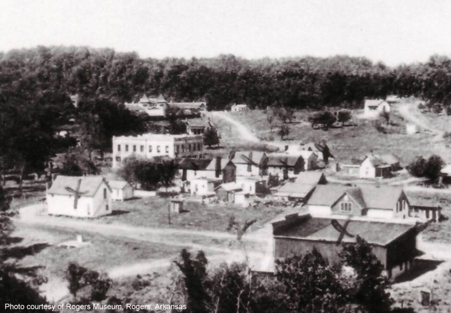
Monte Ne Circa 1910 - This is old Monte Ne in its prime. Oklahoma Row with its concrete tower can be easily identified in the background. The Bank Block is very obvious in the downtown area east and down in the valley below the high land where Oklahoma Row was located. There is a rather large building beyond the Bank Block in the area where Missouri Row was supposed to have been and there is a white roofed building closer to Oklahoma Row. The frontier fort architecture of Missouri Row is not apparent in the photo though. The square wooden facade of the old store/postoffice blocks part of the view of the lower right side of the Bank Block. Is that a reflection from a pool of water through the opening in the trees below and this side of the tower and to the left of the Bank Block or is it a building with white walls, dark roof, and two windows? The lagoon should have been in that area.
|
|---|
|
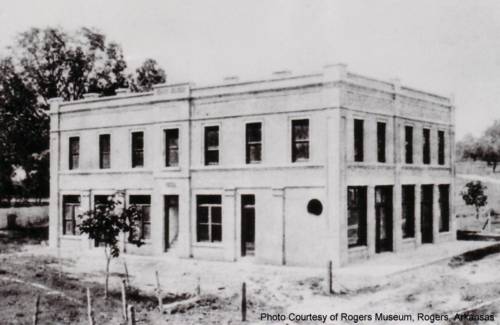
The Monte Ne Bank Block Circa 1905
This photo of the Bank Block appears to have been made soon after the bank was built. The bank closed around 1914. |
|
|---|
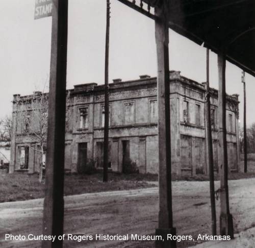
| The Monte Ne Bank Block Shell |
|
This photo was made from the porch of the store/post office across the street after the Bank Block had been gutted. It seems to have been made in the late 40's or early 50's. |
|
|---|
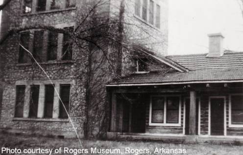
| The Oklahoma Row Log Hotel with Tower |
|
Oklahoma Row was completed in 1910. Across the lawn to the east of Oklahoma Row was Missouri Row. Harvey had originally planned to build two more, but they were never built. My guess is that this photo is from the 50s, but could have been anytime. The quality of the photo makes me think 40s to early 60s. It shows important details of the way the Oklahoma Row log structure connected to the tower. The first floor of the tower could be entered through a door from either porch. A stairway from the porch led to the second floor. The door in the corner left of the two windows opens to the stair. The slant roof that cuts into the gable roof provided clearance at the second floor level. A stairway inside the tower's second level provided access to the third floor. |
|
|---|
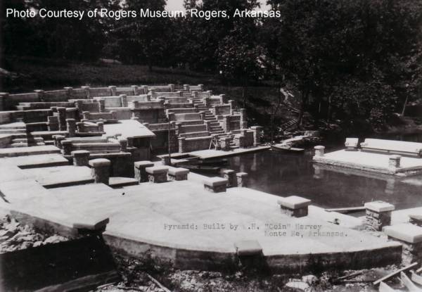
| The Amphitheater under Construction |
|
Harvey began construction of the amphitheater in 1926 and completed it in 1928. He built the amphitheater to serve as the foyer for his planned "pyramid." The amphitheater was still under construction when this photo was made, but it was almost complete. Construction of the 'couches' at the north end of the west wall had not been started. The steps at the bottom of the broad stair were finished but a modification was added later. The concrete walkway going further north along the bank to a seat of some sort is clearly visible in this photo. There is a little stand of some sort in the corner. It seems that several other things were added to the near side also after this photo was made. |
|
|---|
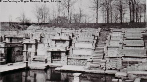
| A Later Stage of Amphitheater Construction |
|
This photo is interesting because a ravine is visible behind the amphitheater. A small hill is there now. Could that have been an excavation in preparation for the foundation of the pyramid or had the ravine been there all along? Notice that by this time the series of four couches has been completed at the north end of the west wall and the lower steps of the broad stair have been changed. The little platform with three steps up each side has been added and the stair steps from the bottom to about half way up have been raised to match the top of the platform. |

|
This is the southwest corner where the south and west walls join. The sign says "Pamphlets sold here giving life story of Mr. Harvey with his reasons for building the pyramid and a picture of it as it would have looked if completed." Below that, written in script, is "When stand is closed they may be had at white house on hill." |
|---|---|
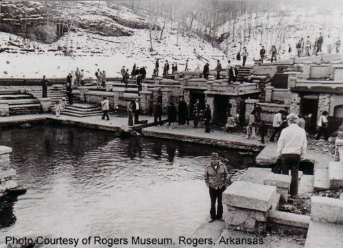
| Amphitheater Detail - July 1957 | |

|
|---|
| Amphitheater Podium with Entrance Demolished - Circa 1964 |
|
This is the amphitheater podium after the Army Corps of Engineers started getting the area ready for the lake. The ticket booth at the amphitheater entrance has been knocked down, but the podium chairs have not been removed. It looks like Oklahoma Row is still on its foundation by the tower. The lagoon has been drained, but the column beside the spring outlet channel (lower left) is still standing. |
|
|---|
| Amphitheater After Ten Years Under Water |
|
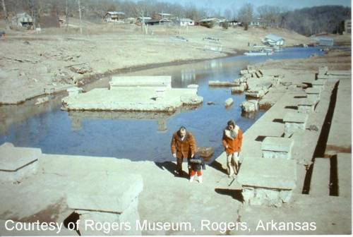
This is the amphitheater during the winter in early 1977. Snow covers the hillside beyond the amphitheater. A severe drought and lake control operations allowed the lake level to drop to about 1092 feet above sea level. By July 1977 the lake was back at 1107 feet, which was still low. The channel in the walkway in the center is one of the outlets for the spring. The columns that used to stand on each side where it enters the lagoon have been knocked down. |
|
|---|
| Amphitheater After Ten Years Under Water |
|
This photo by Don Roemer was taken during winter time in early 1977 when the lake level was very low. It was taken at the same time as the bridge photo. The ruins of the entrance building are still there. The columns around the boat dock have been knocked down. |
|
|---|
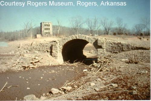
| Concrete Arch Bridge After Ten Years Under Water |
|
One of the concrete bridges that spanned the channels of the lagoon system. There were at least two of these bridges. This one seems to have been the simpler of the two. The photo shows part of a structure at the shore line on the right and the cubical block building near the tower is still standing. |
| See bottom of this page for LINKS TO OTHER WEB SITES RELATED TO MONTE NE AND COIN HARVEY |
| THE INDEX OF PAGES FOR THIS ARTICLE |
| PAGE 1 - The story of Coin Harvey and Monte Ne with photos of the amphitheater. |
| PAGE 2 - Concrete Bank Block Building and Views of the Lagoon |
| PAGE 3 - Lodge, Burial Vault, and Photos with the Lake at Three Levels |
| PAGE 4 - 1977 Lake Level marked on Old Photos, Views into the Water, Checking the Time Capsule, Related Links |
| PAGE 5 - Lissa Myer's Current photos of the ruins at Monte Ne: the Tower Windows, old foundations, and crowds at the amphitheater. |
| PAGE 6 - 2005 Views of Oklahoma Row foundation and tower with a new summary of the events of William Hope "Coin" Harvey's involvement with his Monte Ne Resort and the good roads movement. This page includes many links to other informative web sites related to Coin Harvey and Monte Ne. |
| PAGE 7 - Photo and map of the old townsite with a panoramic photo of some of the foundation ruins on the lake shore and across the lake to the amphitheater. There is a photo that shows the new location of Harvey's tomb. The text includes some comments from a U.S. Corps of Engineers employee who toured the Monte Ne site for the Corps in the early 60s. |
| PAGE 8 - Coin Harvey's Amphitheater around the Big Spring at Monte Ne. Harvey planned this to be the foyer for his pyramid or obelisk in which he planned to place a"time capsule" or museum room to hold all the important documents and marvels of civilization. However, that was never to be because he was unable to obtain financing. The photos on this page show the upper parts of the amphitheater now exposed by the dropping waters of Beaver Lake. Old photos from before the lake was built and at other times when the lake was low are included for comparison. |
| PAGE 9 - This page continues the amphitheater description with the south wall. Most of the south wall is under water even with the lake level at 1106 feet above sea level. The south wall may have been the planned entrance to the pyramid and time capsule that Coin Harvey wanted to build. In any case, he probably planned to build the pyramid, or obelisk, on the little hill behind the amphitheater. That little hill is an island when the lake level gets to the 1120 to 1125 range as shown in the photo posted on the previous page. |
| PAGE 10 - On the side of the hill behind the south wall is a tall retaining wall. The area was so covered in brush in 1961 and I was so hesitant about the possibility of trespassing that I didn't find that wall. There is a paved driveway leading from the east of the amphitheater up to the area above the wall where the railroad depot used to be. There are also panoramice photos of the view from the amphitheater back toward the old Monte Ne town site. |
| PAGE 11 - Selected Monte Ne Resort photos from the Rogers Historical Museum used by permission. Photo of old Monte Ne in great detail. Photos of the Bank Block when new and years later after it had been gutted by fire or weather. Photos of the amphitheater from its unfinished construction stage in 1928 and when that part of Beaver Lake was dry in the winter of 1977. |
| PAGE 12 - 2006 Wedding in the Monte Ne amphitheater. First wedding there in more than 40 years? Photo of Ann in the amphitheater in 2006 compared to a similar photo from 1977. |
| PAGE 13 - Photos comparing the low lake level in January 2006 with the same areas in January 2007 after the lake level rose about 20 feet. |


Friends of Monte Ne!Can the Friends of Monte Ne be reorganized now that there is such great interest in the lost resort? With proper organization, planning, and fund raising, some nice things could be done in the area by the Lake at old Monte Ne.
It would help to have someone with connections to the local district of the Army Corps of Engineers, the State Parks Department, and maybe some of the local politicians. If you're interested, e-mail me at jamesmskipper1141@att.net and I will pass it on to the interested people who live in the area. |
|
SUPPORT Pearland Meals on Wheels A Ministry of Pearland Churches |
|---|
| Skipper Family Magazine SITE INDEX PAGE |
 For a definitive picture album/history of the resort at Monte Ne, purchase Allyn Lord's - Historic Monte Ne published by Arcadia Publishing in its Images of America series. For a definitive picture album/history of the resort at Monte Ne, purchase Allyn Lord's - Historic Monte Ne published by Arcadia Publishing in its Images of America series.
|
Posted: 2/6/06