
Click the image to see at 1000 pixel-wide version.
 |
 Dotted Lines indicate approximate water level shown in the 1977 photo above. |
|---|

| 
|
| |
Dotted Lines indicate approximate water level shown in the 1977 photo above. |
|---|
|
|
|
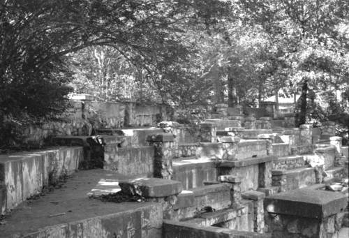
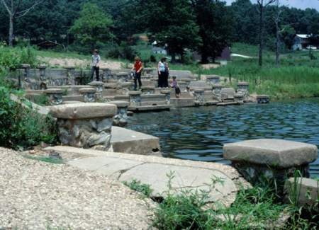
In 1977 the level of Beaver Lake (usually about 1110 -1120 feet above sea level) dropped enough to expose the upper part of the Monte Ne amphitheater. I have seen a newspaper photo from 1977 that shows the water level actually down to the original lagoon level and people are walking on the flat level surrounding the water in front of the podium. My family provide the human scale for the structure. The dotted lines across the old photos show the approximate water level at that time. At least two thirds of the structure was still below the surface. Click the old photos to see larger images.
 |
 |
|
|---|---|---|
| Monte Ne Amphitheatre in July 1977 Click for 1000 pixel-wide versions. |
||
| Central Area of West Wall | North End of West Wall | |
| 
| 
|
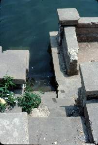
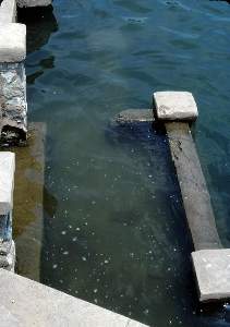
The three other color photos show views looking into the water. The photo on
the left shows some narrow steps leading to the bottom. The steps are on the other side of the walled area with the single drain in the photo above. The narrow stair is plainly visible in the photo marked with the water line higher on the page. The center photo is near the
corner of the amphitheater and the one on the right is on the back wall where
the wall, itself, drops off as shown on the left of the old photo on the left.
 Approximate lake levels (in feet above Sea Level) are marked on the photo - 1120' is normal |
|---|

| 
|
In the photo on the left is the group that gathered in the spring of 1963 to
see whether someone would try to dig up the rumored time capsule before the
amphitheater was flooded by the waters of Beaver Lake. The photo on the right is
a current photo of me taken in one of the concrete chairs recovered from the
Beaver Lake or removed before the area was flooded initially. The two chairs are located in Rogers, Arkansas, in Frisco Park
across from the Daisy B-B Gun museum.
| See bottom of this page for LINKS TO OTHER WEB SITES RELATED TO MONTE NE AND COIN HARVEY |
| THE INDEX OF PAGES FOR THIS ARTICLE |
| PAGE 1 - The story of Coin Harvey and Monte Ne with photos of the amphitheater. |
| PAGE 2 - Concrete Bank Block Building and Views of the Lagoon |
| PAGE 3 - Lodge, Burial Vault, and Photos with the Lake at Three Levels |
| PAGE 4 - 1977 Lake Level marked on Old Photos, Views into the Water, Checking the Time Capsule, Related Links |
| PAGE 5 - Lissa Myer's Current photos of the ruins at Monte Ne: the Tower Windows, old foundations, and crowds at the amphitheater. |
| PAGE 6 - 2005 Views of Oklahoma Row foundation and tower with a new summary of the events of William Hope "Coin" Harvey's involvement with his Monte Ne Resort and the good roads movement. This page includes many links to other informative web sites related to Coin Harvey and Monte Ne. |
| PAGE 7 - Photo and map of the old townsite with a panoramic photo of some of the foundation ruins on the lake shore and across the lake to the amphitheater. There is a photo that shows the new location of Harvey's tomb. The text includes some comments from a U.S. Corps of Engineers employee who toured the Monte Ne site for the Corps in the early 60s. |
| PAGE 8 - Coin Harvey's Amphitheater around the Big Spring at Monte Ne. Harvey planned this to be the foyer for his pyramid or obelisk in which he planned to place a"time capsule" or museum room to hold all the important documents and marvels of civilization. However, that was never to be because he was unable to obtain financing. The photos on this page show the upper parts of the amphitheater now exposed by the dropping waters of Beaver Lake. Old photos from before the lake was built and at other times when the lake was low are included for comparison. |
| PAGE 9 - This page continues the amphitheater description with the south wall. Most of the south wall is under water even with the lake level at 1106 feet above sea level. The south wall may have been the planned entrance to the pyramid and time capsule that Coin Harvey wanted to build. In any case, he probably planned to build the pyramid, or obelisk, on the little hill behind the amphitheater. That little hill is an island when the lake level gets to the 1120 to 1125 range as shown in the photo posted on the previous page. |
| PAGE 10 - On the side of the hill behind the south wall is a tall retaining wall. The area was so covered in brush in 1961 and I was so hesitant about the possibility of trespassing that I didn't find that wall. There is a paved driveway leading from the east of the amphitheater up to the area above the wall where the railroad depot used to be. There are also panoramice photos of the view from the amphitheater back toward the old Monte Ne town site. |
| PAGE 11 - Selected Monte Ne Resort photos from the Rogers Historical Museum used by permission. Photo of old Monte Ne in great detail. Photos of the Bank Block when new and years later after it had been gutted by fire or weather. Photos of the amphitheater from its unfinished construction in 1928 and when that part of Beaver Lake was dry in the winter of 1977. |
| PAGE 12 - 2006 Wedding in the Monte Ne amphitheater. First wedding there in more than 40 years? Photo of Ann in the amphitheater in 2006 compared to a similar photo from 1977. |
| PAGE 13 - Photos comparing the low lake level in January 2006 with the same areas in January 2007 after the lake level rose about 20 feet. |
| Skipper Family Magazine SITE INDEX PAGE |


Friends of Monte Ne!Can the Friends of Monte Ne be reorganized now that there is such great interest in the lost resort? With proper organization, planning, and fund raising, some nice things could be done in the area by the Lake at old Monte Ne.
It would help to have someone with connections to the local district of the Army Corps of Engineers, the State Parks Department, and maybe some of the local politicians. If you're interested, e-mail me at jamesmskipper1141@att.net and I will pass it on to the interested people who live in the area. |
|
SUPPORT Pearland Meals on Wheels A Ministry of Pearland Churches |
|---|
 For a definitive picture album/history of the resort at Monte Ne, purchase Allyn Lord's - "Historic Monte Ne" published by Arcadia Publishing in its Images of America series. For a definitive picture album/history of the resort at Monte Ne, purchase Allyn Lord's - "Historic Monte Ne" published by Arcadia Publishing in its Images of America series.
|
Re-posted: 11/12/02
and 3/3/05